Documents
Poster
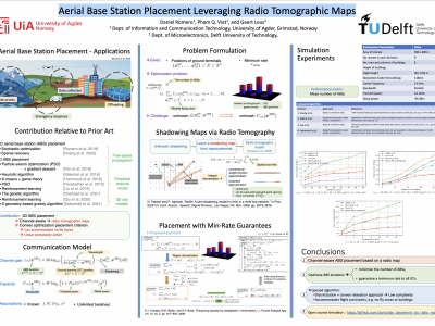
Aerial Base Station Placement Leveraging Radio Tomographic Maps
- Citation Author(s):
- Submitted by:
- Daniel Romero
- Last updated:
- 6 May 2022 - 4:19pm
- Document Type:
- Poster
- Document Year:
- 2022
- Event:
- Presenters:
- Daniel Romero
- Paper Code:
- SPCOM-6.3:
- Categories:
- Keywords:
- Log in to post comments
Mobile base stations on board unmanned aerial vehicles (UAVs)
promise to deliver connectivity to those areas where the
terrestrial infrastructure is overloaded, damaged, or absent. A
fundamental problem in this context involves determining a
minimal set of locations in 3D space where such aerial base
stations (ABSs) must be deployed to provide coverage to a set of
users. While nearly all existing approaches rely on average
characterizations of the propagation medium, this work
develops a scheme where the actual channel information is
exploited by means of a radio tomographic map. A convex
optimization approach is presented to minimize the number of
required ABSs while ensuring that the UAVs do not enter no-fly
regions. A simulation study reveals that the proposed algorithm
markedly outperforms its competitors.

